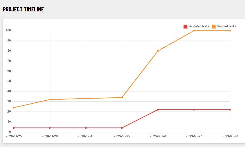
The Longford town task had been created in 2020, but was then “parked”, because the large choice of tasks hindered the completion of any of them. It was revived after the completion of the Roscommon task and finished within less than a week. The best quality imagery was Esri Clarity which is however quite old at this point in time (estimated 8-12 years, depending on the area).
Contributors
In order of number of contributions, the contributors were b-unicycling, eireidium, NoelB, Jonako, DeBigC, ApolloCreedon, Smef09, Aliciarodrigo_, CjMalone and ibanez. Apart from two of these, most were advanced mappers. Presumably, the other two were from the group of students who had joined us in Roscommon already.
How many and what type of buildings were mapped?
According to ohsome.org, the numbers since 2020-11-25 are
| building type | total number | number increase since 2020 |
| building (total no.) | ~6,000 | ~5,562 |
| yes | ~1,300 | ~1007 |
| house | ~3,900 | ~3780 |
| terrace | 17 | 17 |
| detached | 1 | 1 |
| shed | 192 | 192 |
| garage | 168 | 168 |
| farm_auxiliary | 240 | 240 |
| retail | 19 | 15 |
| industrial | 36 | 30 |
| greenhouse | 8 | 8 |
| school | 3 | 2 |
| church | 3 | 3 |
Landuses
| Landuse Type | Total Area (in m2) | Area Increase (in m2 since Nov 2020) |
| residential | 768,738.2 | 219,909.2 |
| grass | 83,313.6 | 6,446.3 |
| commercial | 101,317.3 | -79.5 |
| industrial | 891185.6 | 0 |
| amenity=parking | 106,706 | 6,844.7 |
| amenity=school | 243,441.3 | 0 |
| leisure=park | 103,404.6 | 0 |
Quo vadis?
As usual, the task needs to be validated and, where possible, the number of building=yes decreased. The main task now open for mapping is Connemara.
1 Comment
Buildings Project 2019-2023 – OpenStreetMap Ireland · 21-Mar-2024 at 09:29
[…] Longford Town […]
Comments are closed.